Discovering NYC Chronotypes with Fused

Β· 3 min read
Elizabeth Cutrone
Director of Data Science @ Precisely

TL;DR Elizabeth Cultrone analyzed NYC Taxi pickup data to identify neighborhood boundaries based on activity patterns. She created a UDF to implement H3 binning and similarity metrics.

Neighborhoods within a city have consistent characteristics but often have ill-defined boundaries. Some neighborhoods are more similar than others even though they're not nearby. Understanding these local boundaries and the demographics, dynamics and behaviors of different areas affects a wide range of business applications, including advertising, site selection, business analytics, and many more.


Earth-scale AI pipelines for Earth Observation (Part 1: Data Curation)

Β· 7 min read
Gabriel Durkin
Data Scientist & Quantum Physicist

TL;DR Fused simplifies how Earth Observation data is processed to curate training data for AI models. Gabriel Durkin shows a Streamlit app he created to train and run land use and crop detection models.


The rate of prototyping the Fused App Builder unlocks is unrivaled. Recently I used it to create a sophisticated prototype app to accelerate my ML workflow. You can follow along by using the "Cube Factory" app I built.

DuckDB, Fused, and your data warehouse

Β· 3 min read
Stefano Bourscheid
Facilitating Engineer @ GLS

TL;DR GLS Studio uses Fused to optimize Snowflake queries. This enables route planning in their ParcelPlanner app with H3-partitioned geospatial data served to a Honeycomb Maps frontend.


GLS (General Logistics Systems) is an international parcel delivery service provider, primarily operating in Europe and North America. To stay ahead in the fast-paced logistics industry, GLS launched GLS Studioβ€”an innovation lab aimed at optimising and modernising its depots and processes through cutting-edge technology.

Stefano co-founded GLS Studio to build the next generation of data-driven products. In this post, he shares how GLS Studio uses Fused to drive efficiency and innovation in parcel delivery.

In this blog post, Stefano shows how his team powers GLS's ParcelPlanner app, which helps GLS evaluate delivery routes efficiently. The app uses Fused to query Snowflake and serve H3-partitioned geospatial data to the frontend, which is powered by Honeycomb Maps and DuckDB WASM.

The Strength in Weak Data Part 2: Zonal Statistics

Β· 3 min read
Kristin Scholten
Data Scientist @ Nationwide

TL;DR Kristin created a UDF to mask cropland areas using USDA data and run a Zonal Statistics workflow for corn yield predictions.


A raster, a vector, and an array walk into a bar…

Ok I will spare you the corny jokes.

But seriously, I was facing a problem with these three data types when I approached Fused. It felt impossible to join this information together in a meaningful way. Fortunately, I was quickly proven wrong with the power of UDFs. Let me catch you up.

Analyzing traffic speeds from 100 billion drive records

Β· 5 min read
Christopher Kyed
Data Scientist @ Pacific Spatial

TL;DR Pacific Spatial Solutions uses Fused to streamline data workflows and feature engineering to predict national traffic risk in Japan.


Over the last few decades, it has become increasingly evident that passenger vehicles are by far the most dangerous way to travel. As a result, it has become more and more important to find an efficient and effective method to predict traffic risk. However, predicting traffic accidents and where they are likely to occur is a very complex problem, with large amounts of data being needed for most meaningful predictions.

At Pacific Spatial Solutions, we are currently trying to tackle this problem by training a machine learning model to predict road and intersection risk in Japan nationwide. As we are trying to predict traffic risk on a national level it is only natural that the data we use cover the same area.

Creating cloud-free composite HLS imagery with Fused

Β· 4 min read
Marie Hoeger
Staff Software Engineer @ Pachama
Plinio Guzman
Founding Engineer @ Fused

TL;DR Pachama partnered with Fused to generate cloud-free HLS image composites, improving tropical forest monitoring and canopy height mapping for carbon conservation projects.


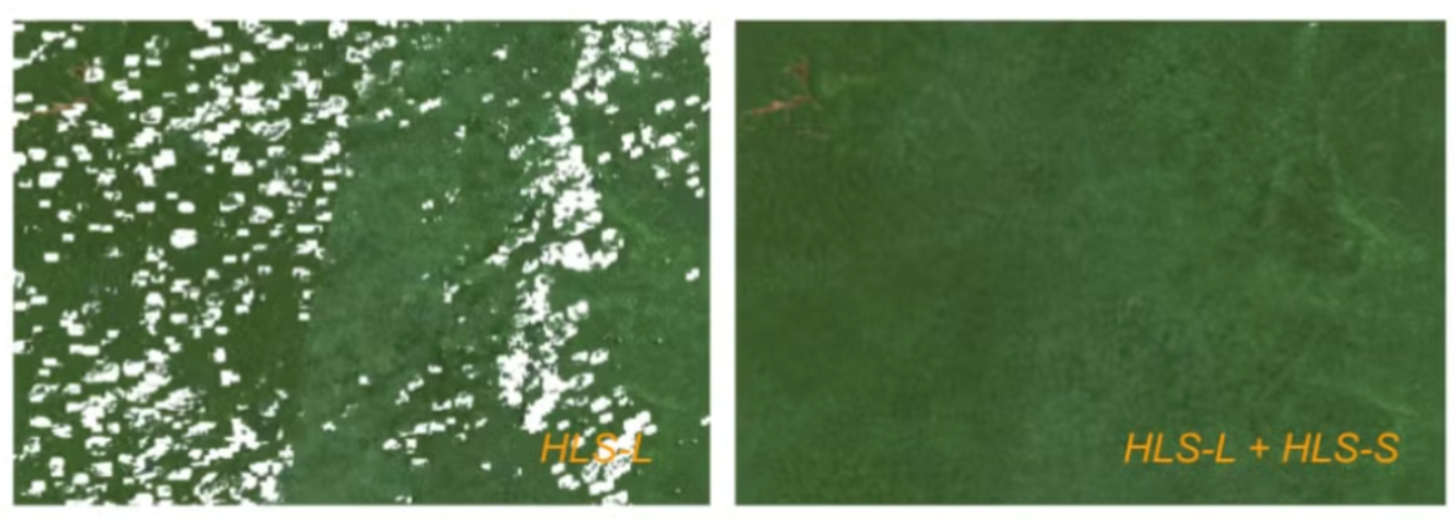
High-quality satellite imagery is essential to assess the carbon impact of nature-based forest conservation and restoration projects [1]. However, getting that high quality imagery is uniquely difficult in areas that need carbon financing the most: tropical forests. Tropical forests present a unique challenge for satellite imagery analysis due to persistent cloud cover, which often renders optical imagery unusable and creates data gaps.

File

Example composites highlight how the HLS-L30 product alone can have gaps when attempting to make a seasonal composite, as fewer cloud-free observations.

The Strength in Weak Data Part 1: Navigating the NetCDF

Β· 3 min read
Kristin Scholten
Data Scientist @ Nationwide

TL;DR Fused streamlined Kristin's workflow to integrate CSV and NetCDF data directly from S3.


Ever tried to make sense of the myriad file types in spatial data science and felt like you've wandered into a linguistic labyrinth? Trust me, you're not alone. As a data scientist who's spent more time wrangling datasets than I care to admit, I thought I'd take a casual stroll down memory lane with an old high school friend: regression models. Just a simple plot of actual vs. predicted, right? But when spatial data's involved, you can't just sit back and relaxβ€”you've got to keep one eye on the geometries.

I'm currently working on an agricultural project, and growing up on a farm gives me a personal stake in this. This blog illustrates my solution to the geometry debacle. I'll first take you to the area where I grew up: Lyon County.

Enrich your dataset with GERS and create a Tile server

Β· 3 min read
Jennings Anderson
Software Engineer @ Meta
Plinio Guzman
Founding Engineer @ Fused

TL;DR Fused enables on-the-fly enrichment of Overture datasets using simple spatial joins.


Overture is an open data project that publishes interoperable map datasets. It aims to foster an ecosystem of developers creating downstream map services around its data products. Fused emerged as a solution to enrich Overture datasets on the fly and serve them with XYZ Tile endpoints.

The App That Finds Your City's Rainfall Twin Globally

Β· 3 min read
Milind Soni
Building for the ever curious

TL;DR Milind analyzes global precipitation patterns using H3 indexing, cosine similarity, and Earth Engine data to create an interactive rainfall comparison app.


This article explores a User Defined Function (UDF) that utilizes global precipitation data to compare rainfall patterns between different locations worldwide and then creates an interactive app!